


 Dan’s Biz Bookshelf: 'This Is Strategy: Make Better Plans'
 The Chemical Connection: Reducing Defects in Circuit Board Production
 It’s Only Common Sense: Trust Is All You Need


NEC Technology Reliably Measures Sea Levels from a Greater Distance
July 16, 2024 | JCN NewswireEstimated reading time: 2 minutes
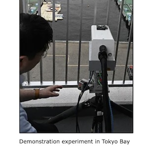
NEC Corporation has developed a technology for measuring sea levels with high accuracy from greater distances using 3D Light Detection And Ranging (LiDAR), a remote sensing technology. This technology makes it possible to reliably measure sea levels, even in the event of a tsunami or ground movement at the location where the measuring equipment is installed. In June 2024, NEC conducted a demonstration test of this technology in Tokyo Bay and confirmed that it can measure sea levels with high accuracy from a greater distance than conventional technologies.
Background
In the event of a tsunami caused by an earthquake, volcanic eruption, or other phenomenon, immediate and accurate assessment of changes in sea levels is critical to saving lives. Current radio wave and float-type sea level measurement systems have a measurement range of about 20 meters from the surface of the sea. However, if ground movement occurs due to an earthquake or other phenomenon, it becomes difficult to measure sea levels. In fact, ground movement due to a major earthquake that occurred on the Noto Peninsula of Japan in January 2024 disabled measurement equipment along part of the coastline, resulting in a delay before reliable measurements could be resumed.
About the New Technology
This new technology delivers 3D-LiDAR infrared laser beams to buoys floating on the sea, and reflected light is used to measure the distance. This ultra-sensitive optical reception is accomplished using long-range 3D-LiDAR with advanced long-range, large-capacity optical transmission and reception technology (coherent reception technology), making it possible to obtain the 3D point cloud data of objects from greater distances. As a result, this is the first time that sea levels have been successfully measured from a distance of 60 meters from the sea with an error of about 2cm. In addition, a 3D water level measurement technology has been developed that clusters processing of the acquired 3D point cloud data, classifies the shape of buoys and surrounding topography with high precision, and then compares the information to correct the position and estimate the height of buoys. This makes it possible to measure from a variety of locations and angles, meaning that 3D-LiDAR equipment can be installed in a wider variety of locations.
3D point cloud data scanned by 3D-LiDAR
As a result, tide stations may be installed in locations along the coastline that are less susceptible to significant ground movement, making the system disaster-resistant and enabling continuous monitoring of sea levels. In addition, the equipment is portable and may be flexibly installed across a wide range of locations, helping to reduce installation costs and time.
Future Developments
Going forward, NEC plans to continue developing this technology, including extending the measurable distance to several hundred meters and improving measurement accuracy by comparing 3D-LiDAR data with map information of the surrounding area, aiming for practical application by the end of FY2025.
Share on:


Suggested Items
IDC Increases its PC and Tablet Forecasts Despite Tariff Uncertainty
06/02/2025 | IDCAfter recording strong results in the first quarter of 2025, IDC is increasing its traditional PC forecast for 2025 — this comes despite the significant impact that US tariffs have had on its trading partners’ market sentiment.
IonQ Signs MoU with KISTI to Accelerate South Korea’s Role in the Global Quantum Race
06/02/2025 | IonQIonQ, a leading commercial quantum computing and networking company, today announced the signing of a memorandum of understanding (MoU) with the Korea Institute of Science and Technology Information (KISTI), a leading national science and technology research institute and supercomputing center.
Stephen Winchell Appointed DARPA Director
06/02/2025 | DARPAStephen Winchell was sworn in today as the 24th director of the Defense Advanced Research Projects Agency.
Saab Equips Swedish Visby-class Corvettes with Enhanced Air Defence Capabilities
06/02/2025 | SaabSaab has been awarded a contract by the Swedish Defence Materiel Administration (FMV) to equip the Swedish Navy’s five Visby-class corvettes with the Sea Ceptor air defence system from MBDA.
Hon Hai Research Institute Partners with Taiwan Academic Research Institute and KAUST to Participate in CLEO 2025
05/30/2025 | FoxconnThe research team of the Semiconductor Division of Hon Hai Research Institute, together with the research teams of National Taiwan University and King Abdullah University of Science and Technology in Saudi Arabia, has successfully made breakthroughs in multi-wavelength μ -LED technology to achieve high-speed visible light communication and optical interconnection between chips.